Colonial settlement
Land wars
The 'Frontier Wars' in the Eastern Cape
Europeans who came to stay in South Africa first settled in and around Cape Town. As the years passed, they sought to expand their territory. This expansion was first at the expense of the Khoikhoi and San, but later Xhosa land was taken as well. The Xhosa encountered eastward-moving White pioneers or ‘Trek Boers’ in the region of the Fish River (near Grahamstown, between Port Elizabeth and East London). The ensuing struggle was not so much a contest between Black and White races as a struggle for water, grazing and living space between two groups of farmers.
Nine Frontier Wars followed between the Xhosa and European settlers, and these wars dominated 19th century South African History. The first frontier war broke out in 1780 and marked the beginning of the Xhosa struggle to preserve their traditional customs and way of life. It was a struggle that was to increase in intensity when the British arrived on the scene. The Xhosa fought for one hundred years to preserve their independence, heritage and land, and today this area is still referred to by many as Frontier Country.
English Settlement
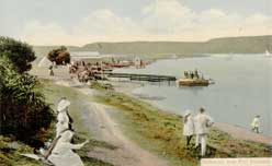
 Redhouse, near Port Elizabeth. c1903 - 1920s. Frescura collection
The first immigrant structure in Port Elizabeth was erected by the British in August 1799. Named Fort Frederick, after Frederick, Duke of York, its main function was to guard the landing place and water supplies at Algoa Bay. It is also probable that the British intended to establish a military presence in the region to deter potential Dutch uprisings in the district of Graaff-Reinet, and to protect Cape Town, and hence the India sea route, from possible French attack. The township of Port Elizabeth was laid out in 1815, but was not developed until 1820 when some 5000 British settlers arrived in the Eastern Cape. The economic development of the village was initially slow. James Backhouse (1844), who visited the place in December 1838, reported that:
"Port Elizabeth is situated on the foot of a steep hill, at the margin of Algoa Bay; it is much like a small, English sea-port town, and contains about 100 houses, exclusive of huts; the houses are of stone or brick, red-tiled, and of English structure. The town is said to have been chiefly raised by the sale of strong drink."
Thus at its onset Port Elizabeth served predominantly as a service centre for the agricultural hinterland of the Eastern Cape. Its basic function was to handle, and later process, goods and materials passing through its harbour. However, developments elsewhere in the southern African interior provided economic stimulus to the new town, and by the 1860s it had overtaken Cape Town as the Colony's premier port.
The growth of an ostrich feather industry in Graaff-Reinet, Oudtshoorn and the Albany, the discovery of diamonds in the Northern Cape and of gold in the Transvaal, and the outbreak of wars against the Boer Republics, were all to benefit Port Elizabeth. As a result, in the early years of the twentieth century, numerous manufacturing industries began to be established locally, most notable being a number of motor vehicle assembly plants, which created extensive employment opportunities. This, as well as increasing rural poverty in the region, attracted many workers to the town to the point that, until the 1960s, it maintained its place as South Africa's third largest urban centre.
Port Elizabeth, as it stands today, owes its form to a number of physical and historical constraints. However, since the early 1900s, colonial segregation planning and a policy of statutory racial separation implemented after 1950, has resulted in what has become a prototypical model of the 'apartheid city' or 'the segregated city'.
[PAGEBREAK]
Colonial segregation
 Click on image to enlarge
The early population of Port Elizabeth consisted mainly of Europeans, as well as persons of mixed race which the apartheid system subsequently labelled as ‘Coloureds’ and ‘Cape Malays’. Initially few members of the indigenous population were attracted to the town and, almost from the onset economic status was related to skin colour. Whites held a virtual monopoly over higher paid jobs and consequently could afford better housing in areas which were usually physically removed from ‘other’ groups. Thus segregation was an integral part of early Port Elizabeth, with the industrial areas of South End and North End being predominantly Coloured, while the Central and Western suburbs were mainly White. However, while White attitudes to Coloured and Malay citizens remained relatively tolerant, official policies toward indigenous residents were markedly different.
Thus, as a rising number of Black workers began to enter Port Elizabeth seeking employment, so then a number of so-called ‘locations’ began to be established on the outskirts of the White suburbs. Rosenthal (1970) has defined locations as being: "Large Native Reserves as well as small areas in municipalities earmarked for residence by Africans".
The pattern was first established in 1834 when the Colonial Government made a grant of land to the London Missionary Society (LMS) to provide a burial ground and residential area for "Hottentots and other coloured people who were members of the Church" (Baines, 1989). This was located at the crest of Hyman's Kloof, better known today as Russel Road. Other workers however chose to erect their homes closer to their places of employment, or where a supply of potable water was available. The major Black suburbs of that time were:
- Bethelsdorp (1803)
- Fingo and Hottentot Location (1830s)
- LMS Outstation (1834)
- Dassiekraal (c1850)
- Korsten (1853)
- Stranger's Location (1855)
- Gubbs Location (1860)
- Cooper's Kloof Location (1877)
- Reservoir Location (1883)
 Click on image to enlarge
With few exceptions these Black suburbs were informal in nature, and residents there were forced to endure living conditions which contemporary observers described as being squalid and open to exploitation by capitalist landlords. Many Whites considered them to be unhealthy and petitions were repeatedly organised demanding that they be removed to the outskirts of the town. These requests were in direct opposition to the needs of the growing commercial and industrial sectors which preferred to locate their labour sources close to the harbour and the inner city area. These conflicting vested interests created political tension within the Port Elizabeth Council which were only resolved in 1885 when the Municipality adopted its first set of markedly segregationist regulations.
As a result suburbs for the exclusive use of Black residents who were not housed by employers, and who could not afford to purchase property, were established on the outskirts of Port Elizabeth. Most prominent amongst them were:
- Racecourse (1896)
- Walmer (1896)
- New Brighton (1902)
In 1901 an outbreak of Bubonic plague struck the town. This was the direct result of Argentinian fodder and horses being imported into South Africa by the British military during the Anglo-Boer conflict (now referred to as the South African War). These cargos also carried plague-infected rats, and although many members of the White and Coloured communities were also affected, the Black population bore the brunt of the Plague Health Regulations. In 1902, most of Port Elizabeth's old locations were demolished (with the exception of Walmer), their resident's personal belongings were arbitrarily destroyed, and restrictions were imposed upon inter-town travel. Although these curbs might initially have been necessary, they were only loosely applied to Whites, and were maintained upon the lives of Black residents well after they were eased elsewhere, this in spite of repeated complaints by the community's leaders.
North End
North End was developed as a mixed land-use suburb immediately north of the Port Elizabeth city centre. It seems probable that, initially, settlement was centred around a trading store run in 1861 by Anne Rich, located opposite the North End jail.
South End
South End was a suburb of Port Elizabeth located south of its commercial centre, and was originally considered by local citizens to be'over the river'. Settlement began in the 1860s when a few fine houses were erected in the area. After the stabilization of sand dunes began in the 1870s, there was a marked increase in its residential development, and when, in the 1880s, the Railways began to expropriate land between South End and the town centre belonging to the Malay community, these families were resettled in South End. Thereafter the suburb began to develop a racially-mixed, working class character which it retained until the 1960s when residents who did not qualify as Whites under South Africa's apartheid laws, were forcibly removed to specially designated areas north of the city.
Korsten
The suburb of Korsten was named after Frederick Korsten, one of the first traders to settle at Algoa Bay. It was established in 1896, but only began to develop after 1902 when, following an outbreak of bubonic plague in Port Elizabeth, the town's Black population was forcibly resettled in nearby New Brighton.
New Brighton Location
The racially segregated suburb of New Brighton was established in 1902 on the outskirts of Port Elizabeth, some 8km north of the city centre, to house families who had been displaced during the plague outbreak. By 1911 its population had grown to 3,650 persons, almost all of them black (Taylor 1991).
Because New Brighton was located relatively far from the centre, many families preferred to settle in Korsten which, at the time, was beyond the Port Elizabeth municipal boundary, but was still substantially closer to town. Korsten also had a substantially more relaxed attitude towards the brewing of illegal liquor, an activity to which many families turned to as a strategy to balance their monthly household budgets.
Therefore, during the colonial period, the location system created a pattern of residential segregation based upon perceived racial and economic differences. However such divisions proved to be only partial, and it was only the implementation of Apartheid Group Areas legislation after 1950 which brought about a structural separation of Port Elizabeth's residential areas. Nonetheless it was during this time that the seeds of the ‘Apartheid City’ were sown.


