After the Anglo-Boer War, there were six British colonies in South Africa. They were all separate, with their own governments. In 1910 four of the colonies were brought together as the Union of South Africa. The four old colonies became the provinces of the Union, namely the Cape Province, the Orange Free State, the Transvaal, and Natal.
In 1961 the Union of South Africa became independent from Britain. This means that it was not a British colony anymore. The name of the country changed to the Republic of South Africa. Today it is still the name, but everybody calls it South Africa.
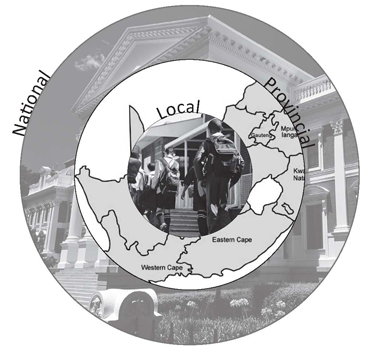
In 1993 with the preparations for democracy, the country was divided into nine provinces. These provinces included the old homeland territories.
The other two colonies were the smaller kingdoms of Swaziland and Basotholand. Today, Basotholand is called Lesotho. These also became self ruling and independent from Britain as separate countries from South Africa.
Cape Province
The Cape Province’s official name was the Province of the Cape of Good Hope. It was the biggest of the four South African provinces.
Cape Town began as a small trading post run by the Dutch East India Company (DEIC) from the Netherlands. Sailing ships on their way to India could stop to rest, do repairs and restock. This trading post was started by Jan van Riebeeck, who arrived in 1652. At first most of the Europeans worked for the DEIC, but later, more and more Europeans chose to come to the Cape to settle. They moved away from Cape Town and started farms and little towns to the north and east. The Europeans included Dutch, French and German people. There were also slaves in the Cape, brought from Africa, Malaysia and other parts of the east, to serve the people from the DEIC. When the Europeans came to the Cape, they came into contact with the native Khoikhoi people. The two groups had very different ways of life, and there were many clashes between them.
In 1806 Britain took over the Cape from the Dutch East India Company. This caused unhappiness among the White farmers especially those on the eastern border of the Cape Colony. They were mostly Afrikaans, and did not want to be ruled by the British. The eastern border was very far from Cape Town, the capital. In those days, it was much more difficult to travel and it took a lot longer than today. This meant that the government did not have as much control over the places that were far away from Cape Town, so the farmers had to look after themselves and were basically free to do what they wanted. But when the British took over, they wanted more control over the eastern border.
When the British government of the Cape spread their control to the east, they also fought with the local Xhosa inhabitants. There were nine wars between the government and the Xhosa, called the frontier (pronounced ‘front-ear’) or border wars. The Dutch farmers also fought with the Xhosa over land. In the end, in about 1838, thousands of these farmers moved away from the Cape Colony to the north. This migration is called the Great Trek.
The Cape stayed a British colony until it became one of the four provinces of the Union of South Africa in 1910
Transvaal
When the Dutch or Afrikaner Boers left the Cape with the Great Trek, they moved north. They did not all move together. There were different groups, called trek parties, and the people who moved were called Voortrekkers. The Voortrekkers wanted their own land where they would not be controlled by the British and where they did not have to fight for land all the time, as they did with the Xhosa on the eastern border of the Cape. When they moved inland, some of the Voortrekker groups thought the land was uninhabited. There were big open spaces and they thought that they could take the land for themselves.
They got this idea possibly because many of the Black groups moved around. One reason for this was to flee from the Zulu king Shaka, who started wars with the groups around him. This was called the mfecane or difaqane, which means something like ‘to flee’ or ‘to break up’. Although the Voortrekkers thought that nobody lived there, some of the groups moved back after the mfecane. There were many clashes between them and the different Voortrekker parties. Black communities included the Ndebele, the Pedi and the Batlou. When the Voortrekkers won they took the land for themselves. The Voortrekkers founded towns, including Potchefstroom and Lydenburg, not far from the Vaal River. In 1852 the area that they had taken over became a republic, called the Zuid-Afrikaansche Republiek or ZAR (this is Dutch for South African Republic). The first president of the ZAR was Marthinus Wessel Pretorius.
In 1877 the British took control of the ZAR. But the Boers did not want to be controlled by the British again, and fought to get their freedom and independence back. This was the first Anglo-Boer War. The Boers won the war and their independence, but only for a little while. Soon another Anglo-Boer War would break out, and this time the Boers would lose.
In 1886, gold was discovered in the ZAR. People from all over the world came to Johannesburg, the new mining town, to find gold. The Boers did not want the foreigners to take their freedom away again and tried to control them very strictly. This angered the British government and they wanted to take over the republic and the gold. This led to the Second Anglo-Boer War or South African War between 1899-1902. The war started in the ZAR, but spread to the whole of South Africa. The other Boer republic, the Orange Free State, helped the ZAR. There were also people from the Cape Colony and even from Europe who came to help the Boers, and Blacks fought on both sides of the war. In the end, the Boers lost and the ZAR and the Orange Free State became British colonies, and the ZAR’s name changed to Transvaal, which means ‘across the Vaal River’.
In 1910 the Transvaal became one of the four provinces of the Union of South Africa.
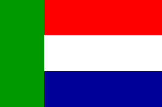 The flag of the Zuid-Afrikaanshe Republiek, the Vierkleur (meaning 'four colour') Source: www.praag.co.za
Orange Free State
When the Voortrekkers moved away from the Cape Colony in the Great Trek, some of them settled just north of the Orange River, which formed the border between the Cape Colony and the rest of South Africa. There, they founded many towns and farms. They soon came into conflict with some of the native groups, especially the Basotho. The Basotho nation was founded by Moshoeshoe during the mfecane. Their capital was at Thaba Bosiu, which means Mountain of the Night in Sotho. In 1854 the Boers (as the Voortrekkers who had settled in the new republics were now called) declared the area the Orange Free State, a Boer republic like the ZAR. They fought against Moshoeshoe many times, mostly over who owned what land and the border between the OFS and the Basotho kingdom. In 1868 the Basotho lost the war against the Boers. Moshoeshoe did not want to lose his kingdom, and asked the British for protection. This meant that the Boers could not take over his kingdom, but it also meant that the British could have control over his land. After Moshoeshoe died in 1870, the British made the kingdom a colony and called it Basotholand. In 1966 Basotholand became independent, and the name was changed to Lesotho.
When the Second Anglo-Boer War broke out in 1899, the Orange Free State helped the ZAR to fight against the British. But in 1902 the Boers lost the war and their republics became British colonies. The name of the Orange Free State was changed to the Orange River Colony. In 1910, it became one of the provinces of the new Union of South Africa, and the name was changed back to the Orange Free State.
Natal
The first people who came to live in Natal were the San and later many Black groups collectively called the Nguni, followed. The Nguni was not one big group or kingdom, but rather small, separate tribes, each one with its own chief. One of these small groups was the Zulu. In 1816 a young man, Shaka became the chief of the Zulu. Shaka was a very good warrior and taught the Zulu army to fight very well. The army, or impis, fought and won many wars against other Nguni and Sotho groups with their skilful military tactics. Shaka included the groups that the impis beat in the Zulu kingdom, so that the Zulus became a very big and strong nation. Not all of the other groups were beaten. Some moved away from Shaka’s area to form their own kingdoms. One such kingdom was the Ndebele under king Mzilikazi, who settled in northern Transvaal and Zimbabwe. Another is the Basotho, who formed their own kingdom in Lesotho under King Moshoeshoe (pronounced Moe-shwe-shwe).
In 1824 British ivory traders came to the shore of Shaka’s kingdom and, with Shaka’s permission, formed a small settlement. In time the settlement grew and became a small town, which they called D’Urban, after the Governor of the Cape Colony. There were about 30 men in this village.
In 1828 Shaka was killed by his half-brothers and one of them, Dingane, became the new Zulu-king. When one of the Voortrekker parties arrived in Zululand and wanted to settle there, they first had to negotiate with Dingane to get some of his land to live on. The Voortrekker party’s leader, Piet Retief, made an agreement with Dingane, and the Voortrekkers believed that they had Dingane’s permission to move over the Drakensberg into his land. But when Retief went to sign the papers at Dingane’s kraal on 6 February 1838, he and the men who went with him were killed. The impis then attacked and killed hundreds of the Voortrekkers, and also attacked the village of D’Urban.
On 16 December 1838 the impis attacked a Voortrekker laager at Blood River. There were thousands of Zulu-warriors and only a few Voortrekkers, but the Voortrekkers won the battle. The day became a very important day for Afrikaners. Before 1994, it was a public holiday called the Day of the Covenant, because the Voortrekkers had promised God that if He helped them in the battle against the impis, they would keep 16 December as a special day. Today, it is still a holiday, but it is called Day of Reconciliation. After the Battle of Blood River (or Ncome River), Dingane lost a lot of his power. The Voortrekkers moved into the land, and began to form towns and districts. It became a Boer republic, called Natalia, which means Christmas. The capital of Natalia was called Pietermaritzburg, a mixture of the names of Piet Retief and Gerrit Maritz, two Voortrekker leaders.
But in 1842 British troops annexed the Republic of Natalia. It became a British colony called Natal. The Voortrekkers (or Boers, as the Afrikaner farmers were called) did not want to be ruled by the British as they had been in the Cape, and most of them left Natal to go and live in one of the other two Boer Republics, the South African Republic (ZAR) or the Orange Free State. In 1879 the British attacked Zululand after years of fights over land. This was the beginning of the Anglo-Zulu War. The captured the Zulu king, Cetshwayo, and sent him into exile. In 1887 they annexed Zululand, and it became part of the Natal Colony.
Natal remained a British colony until 1910, when it became one of the four provinces of the Union of South Africa.
The Homelands
After South Africa became a Union, the government wanted Black and White people to live separately, so they created certain areas, or reserves for Black people. Before the Union they were rural areas ruled by local chiefs. They came to be called ‘Native Locations’ and Black South Africans lost their land through the 1913 Land Act. Later, under apartheid the division of races and control of black people became tighter and these reserved areas were extended to be called bantustans or homelands. The idea was that the homelands would be like countries where Black people could live and vote for their own governments, led by chiefs who were controlled by the apartheid Government. There was a homeland for different language groups like Venda and Xhosa in South Africa. These groups were called nations, and all Black South Africans were made citizens of one of these ‘homeland’ ‘countries’, without any consideration for where they were born or where they lived. This meant forcing millions of people, who became non-citizens of South Africa, to these far off places.
Many people had never even been to the place which they were now supposed to call home. They now had to get permission to come and work in South Africa as if they were foreigners. These ‘homelands’ were home to the workers and regarded as a pool of cheap black labour. They were small making up less than a tenth of the whole country but accomodating almost 90 percent of the people. The land could not support all these people and was of the worst quality so that people were forced to work on mines and in factories in the towns to earn an income. This separated families as fathers left for long periods to work far away from home.
Each homeland had its own leader, installed by the apartheid government. They depended on South Africa for economic survival and so could never challenge the Government. The world refused to recognise the homelands as independent countries.
The homelands were Ciskei, Transkei, KwaZulu, Venda, Bophuthatswana, Gazankulu, KaNgwane, KwaNdebele, Lebowa and Quaqua.
Activity 1 Map of the provinces of South Africa during apartheid. Source:http://www.fotw.net/misc/za(old.gif Fill in the names of the old provinces on the map. a. In which province do you live? b. What is the capital of your province? c. Of which province was it a part before 1993? On the maps, there are pieces of land that have different colours. What were these places called? What were they? Activity 2 Do you know anybody who lived in a homeland? (Like a family member, neighbour, friend or maybe somebody that works for your family.) Ask them about life in the homeland. Ask questions like –
Write their story down in a paragraph or two. |