
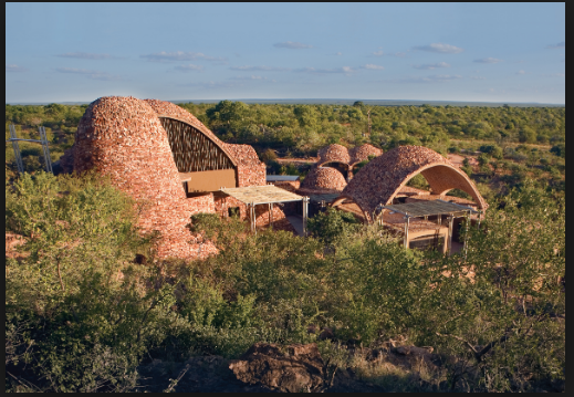
Set in a spectacular but remote veld landscape, Peter Rich Architects’ Mapungubwe Interpretation Centre exemplifies contemporary African architecture. Visible from its entrance gate, the Mapungubwe Centre is approached through a valley from where the outcrop of new buildings merges naturally into the veld!
As you enter the Mapungubwe National Park and World Heritage Site, one of the things that first captures the eye is the architecture of the Museum and Interpretive Centre. The extraordinary curvature and lines of the building will mesmerise all visitors but the true treasures are located inside.
The centre was constructed with the intention of merging the natural location with the park's cultural heritage, by using modern environmentally sensitive techniques. In 2009 the building won the World Architectural Building of the Year Award, out-performing buildings from New York, Singapore and China.The stone-walling technique used in the building of the centre was adopted from a native method prevalent in the Mapungubwe area.
The motivation behind the costruction of such a centre was created when native communities requested the return of the remains and artifacts removed from Mapungubwe in the 1930's. The human remains we reburried. It was decided that the artifacts needed to be displayed in a museum in order to educate and inform visitors of the area's rich heritage.
A short boardwalk ramp leads you to the entrance of the facility, where you will be met by a knowledgeable guide who is eager to share the mysteries of Mapungubwe and one of southern Africa's first trading kingdoms, with you. The museum houses historical artefacts, images and information that tell the story of Mapungubwe's incredle history. The holy grail of the museum is the Golden Rhino which was discovered in a grave in 1932, more than seven centuries after the civilization inhabited the area. The museum tour ends with a short walk to a look-out point where you will be able to see the hill that was, according to legend, the inspiration behind architect Gerard Moerdijk's Voortrekker Monument in Pretoria.
Operating times:
Mondays to Sundays (including public holidays) 8:00 - 16:00
Tariffs:Museum Tour R50 per person. Museum school group tour R15 per person
Golden Rhino Auditorium (accommodates 52 people) R710


