
placeREF P-0151941Revised
Place record
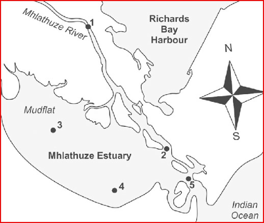
Mhlathuze River
- Coordinates
- -28.7410, 31.4370
- Updated
- 20 Jul 2026
The Mhlathuze River, Meanders Through the Municipal Area and Unifies The Towns, Suburbs and Traditional Areas of Richards Bay!
The Battle of Mhlatuze River was a battle fought between the Zulu and Ndwandwe tribes in 1820, following the Zulu Civil War. The Ndwandwe hierarchy was a largely scattered population after this Battle. The Ndwandwe, with the Mthethwa, were a significant power in present-day Zululand, at the turn of the Nineteenth Century. Under the leadership of King Zwide, the Ndwandwe Nation destroyed the Mthethwa under their king Dingiswayo, and the power vacuum was filled by Shaka Zulu and the Zulu tribe. Zwide makes a mistake by thinking that he can surprise Shaka, and hastily sends off his much greater army to fight the Zulu. In one mighty battle, Soshangana and Zwangendaba fight for Zwide and the Ndwandwe. They faced Shaka, and Mzilikazi (Zwide’s grandson) and Dingane are two of his officers.
Location Map
Mhlathuze River
How we know this
- 01https://saheritagepublishers.co.za/product/battle-of-mhlatuze-river/
Last updated · 20 Jul 2026
South African History Online. (2023, February 16). Mhlathuze River. South African History Online. https://sahistory.org.za/ref/P-0151941
South African History Online (2023) 'Mhlathuze River', South African History Online, 16 February. Available at: https://sahistory.org.za/ref/P-0151941 (Accessed: 17 October 2026).
South African History Online, Mhlathuze River [website], https://sahistory.org.za/ref/P-0151941, (accessed 17 October 2026).
"Mhlathuze River." South African History Online, 16 Feb. 2023, https://sahistory.org.za/ref/P-0151941. Accessed 17 Oct. 2026.
South African History Online. "Mhlathuze River." South African History Online. February 16, 2023. https://sahistory.org.za/ref/P-0151941.
Further reading
 Article
Zulu
The four major ethnic divisions among Black South Africans are the Nguni, Sotho, Shangaan-Tsonga and Venda.
 Article
Zulu Family History
Zulu Kings
1781 to 1816 Senzangakhona
1816 to 1828 Shaka
1828 to 1840 Dingane
1840 to 1872...
 Biography
King Dingane ka Senzangakhona
Dingane ka Senzangakhona was born in 1795 to father Chief Senzangakhona and mother Mpikase kaMlilela Ngobese who was...
 Place
Place
Richards Bay
Once a little fishing Village, Richards Bay is now a busy Harbour Town and popular KwaZulu-Natal Holiday Destination.
 Biography
Phila Portia Ndwandwe
Phila Portia Ndwandwe (also known as Zandile or Zandi) became part of the Natal Machinery of uMkhonto weSizwe (MK) in...
 Biography
Shaka Zulu
Sigidi kaSenzangakhona commonly knows as Shaka was a great Zulu king and conqueror.
SAHO is free because readers fund it. Donate →