The Amatola Region is one of the most beautiful and diverse in the Eastern Cape. The Amathole's stretch into the hinterland just North of Grahamstown and West of Stutterheim, the slopes are covered in dense natural forests of white stinkwoods, yellowwood trees, gorgeous Cape Chestnuts, and a myriad other indigenous trees. Some of the peaks are decked with snow in winter and reach over 2000 metres, providing wonderful forest trails and a prolific bird life.
Nestling in their shadow in the valleys are a cluster of villages, a mission station, churches and towns that line the valleys of an area not only rich in history but in incredible scenery too. This is frontier country and many of the settlements, such as Cathcart, Fort Beaufort and Adelaide began as military outposts, whilst towns like Stutterheim served as a settlement for disbanded soldiers of the British German Legion, hence the name. Other towns like Alice and the beautiful Hogsback have a more peaceful origin - Hogsback first citizens were farmers. With all the languages of the Locals and the immigrants searching for farmland, there could have been a discrepancy with the spelling of Amathole!
Rather than driving straight through the rather arid area between East London and the Amatola mountains, stop on route to take in some of the province's history and culture. Steve Biko's grave is in King William's Town and a wonderful collection of African art is at Fort Hare University. The treasures of the Amatola region are, without doubt, the pockets of original Afro-Montane rainforest that remain protected today - the Knysna and Amatole forests are South Africa’s largest individual forests. The Amatola Hiking Trail, ranked as one of the country’s top mountainous forest-clad walks, is 105 kilometres and six days of strenuous walking, from King William’s Town to Hogsback through immense, spacious indigenous forest, incredible waterfalls, crystal pools and rushing trout streams.
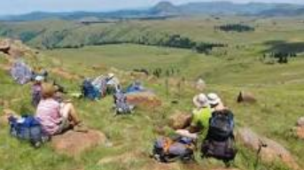
But you don’t have to climb the mountains to benefit from the beauty of the Amatolas. Rambles and walks in the area around Hogsback will take you past clear mountain streams and waterfalls, and provide scenery over which to lose your breath, without the exertion that accompanies a hike.
In the west of the Amatola range is the area known as the Katberg. It is a special experience to climb the Katberg Pass - a rather rough, untarred road - past incredible rocky slopes rich in forest with some of the most remarkable views in the area.


