Place image
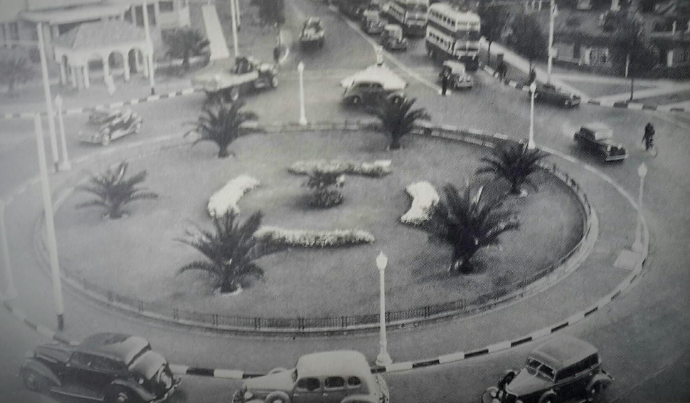
Clarendon Circle was a Landmark Intersection, of the North East Route into Johannesburg. It was a Circle of note Located where East Avenue crossed Empire, Bruce, Twist and Klein Streets. There was an Island on East Avenue, separating the Traffic Lanes with an attractive line up of palm trees and shrubs. Today Clarendon Circle is NO more!
The fingerprint of the History is captured in the name; Clarendon Place which is the new name for, East Avenue. The old Clarendon Circle disappeared into an amorphous, chaotic Crossing marked by Traffic Lights.Clarendon Place which was once Clarendon Circle!
Clarendon Circle was named in honour of the Earl of Clarendon, George Villiers (1877-1955) who served as Governor General of the Union of South Africa from 1931 to 1937. He was the Chief Representative of Britain, in South Africa. George Villiers came from an Aristocratic English Family, with Ancient Roots. His full Name was; George Herbert Hyde Villiers, 6th Earl of Clarendon! He was a British Conservative Politician and sat in the House of Lords. He also served as Chief Scout of the Boy Scout movement during his tenure as Governor General and filled many other Public positions and roles. Today Clarendon, the last Englishman to hold the Post of Governor General of South Africa, is a largely forgotten figure from our Colonial past. However, his name is still remembered in Hotels, Streets, Guesthouses, Apartment Blocks and Schools, throughout South Africa! He was the man who laid the Foundation Stone of the William Cullen Library at the University of the Witwatersrand in 1935. Anna Smith, in her Classic Book: 'Johannesburg Street Names', gives a full record of City Council deliberations for 1931. In October 1931 the Council decided on the name Clarendon Circle following a suggestion by Councillor D W McKay (Mayor, 1936-37) that the roundabout should be named Clarendon Circus which was then modified by Councillor M Freeman (Mayor 1934-35) to Place or Circle. The actual planning of a crucial Road Intersection in the form of a Roundabout went back to 1929, in deliberations of the City Engineers Department. Clarendon Circle was a key intersection leading into the City, or to Hillbrow or West, along Empire Road, and served this purpose over a 28 year period. A Circle meant that vehicles took turns to enter the Traffic Roundabout and then move off in the chosen direction of the Driver. In 1959, it was decided to abandon the Circle in favour of a straightforward intersection to handle growing traffic densities. Over time “traffic” took precedence over a, "living green urban Environment". However, the name Clarendon was retained as what had been East Avenue was renamed Clarendon Place and extended beyond the old Circle and heads towards Klein Street.
References
http://www.theheritageportal.co.za/article/clarendon-circle-then-and-now
Further Reading
https://www.scouts.org.za/
https://www.iol.co.za/news/opinion/joburg-street-names-reflect-fascinating-past-7843469
https://www.abebooks.com/book-search/title/johannesburg-street-names-dictionary-suburb/author/smith-anna/