Mali, landlocked country of western Africa, mostly in the Saharan and Sahelian regions. Mali is bounded on the north by Algeria, on the east by Niger and Burkina Faso, on the south by Côte d’Ivoire and Guinea, and on the west by Senegal and Mauritania. The countryside of Mali is largely flat and arid. The Niger River flows through its interior, functioning as the main trading and transport artery in the country. Sections of the river flood periodically, providing much-needed fertile agricultural soil along its banks as well as creating pasture for livestock.
Although Mali is one of the largest countries in Africa, it has a relatively small population, which is largely concentrated; along the Niger River. The Niger River flows through Mali for slightly more than 1,000 miles (1,600 km), about two-fifths of the river’s total length. It rises in the Fouta Djallon and is of significant size by the time it enters the country near Kangaba. It flows to the northeast across the Mandingue Plateau, its course interrupted by falls and a dam at Sotuba. Reaching Koulikoro, it spreads out in a wide valley and flows majestically to its confluence with the Bani River at Mopti. The Niger then forms an interior delta, because the land is flat and the river’s gradient almost non-existent. The river breaks down into a network of branches and lakes as it continues northward and, at Kabara, eastward. At Bourem the Niger makes a great turn to the southeast, known as the Niger Bend, and flows past Gao and Ansongo to the Niger border at Labbezanga. The soils outside the Niger valley in Mali are poor. In the south, ferruginous (iron-bearing) soils are shallow and form a hard, red crust because of intense evaporation. The desert region is composed of sand, rock, and gravel.
French is the official language of Mali, but languages of the Niger-Congo family dominate. The Bambara (Bamana) ethnic group and language predominate, with several other groups—including the Fulani (Fulbe), Dogon, and Tuareg—also present in the population. Agriculture is the dominant economic sector in the country, with cotton production, cattle and camel herding, and fishing among the major activities. Living in the Sahelian zone and north of the Niger Bend are Imazighen (Berbers, including the Tuareg, a significant subgroup) and the Arab-Spanish-Amazigh (Berber) group known as the Moors, who speak and write Arabic.
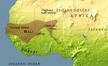
The area that is now Mali was once part of the three great precolonial Sudanic empires: Ghana, Mali, and Songhai. The fabled but now faded trading and learning centre of Timbuktu is situated in Mali on the upper Niger River. For centuries, caravans crossed the Sahara desert from North Africa while others came from the forest regions to the south, meeting at the crossroads of Timbuktu. Other notable towns include Djenné, noted for its famous mosque and other examples of Sudanese architecture, and Mopti, a bustling market centre. The Dogon region, centred on the Bandiagara escarpment in the country’s central area, is an important tourist destination because of its unique cliffside villages and diverse artistic life. The national capital, Bamako, is located on the Niger River and is a rapidly growing city because of increased migration from the depressed rural areas.
There are three main religions. Sunni Islam is practiced by more than nine-tenths of the population, traditional religions by most of the rest, and Christianity (primarily Roman Catholicism and Protestantism) by a small number. Islamization dates to the 11th century and has eclipsed traditional religions among the Soninke, Songhai, Moors, Tuareg, and most Fulani. Many of the Gur-speaking peoples, especially the Dogon, as well as some Malinke and Bambara, practice traditional African religions. Even among Muslim and Christian converts, many traditional beliefs persist.
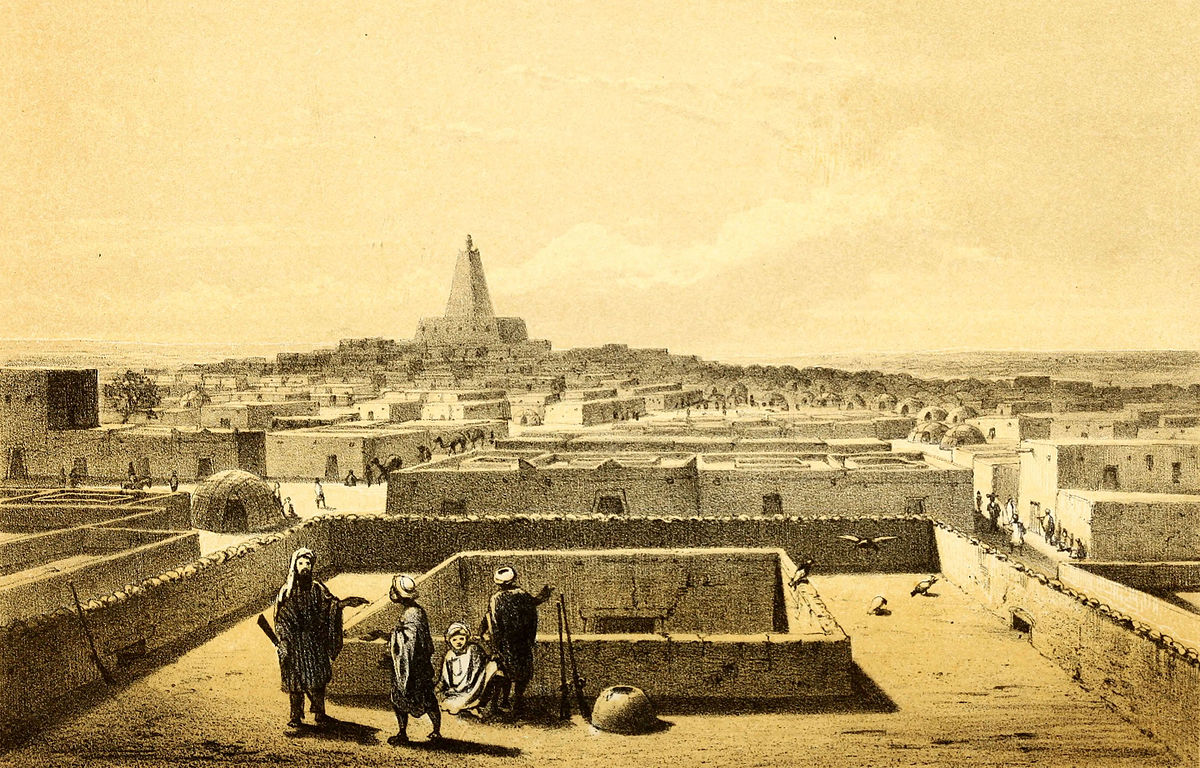
The older towns, such as Djenné, Timbuktu, Gao, and Ségou, are built in the Sudanese style of architecture, characterized by tall mud walls with wooden limbs and planks that stick out from the surface, providing a frame for the mud walls but also creating a type of ladder permitting yearly re-plastering; inside, a series of wooden columns holds up the roof, which has small openings to allow in some sunlight. The Djenné mosque, the epitome of Sudanese architecture, is the largest mud building in the world. Timbuktu (founded about 1100 CE) was a centre of commerce and learning during the time of the Mali (13th–16th century) and Songhai (15th–16th century) empires; later, trans-Saharan trade declined in favour of trade along the Atlantic coast as desertification spread southward, and the town retained only a shadow of its former glory by the early 20th century. The newer towns, such as Bamako, Kayes, San, and Kati, consist of a central business district, around which residential districts are grouped.
The population of Mali (2020) was 20,250,833 people, according to United Nations Data. Life expectancy at birth is still comparatively low. This has risen gradually since 1990 for both males and females, and there has been a slight decline in both birth and death rates, though they remain high, by both world and African standards. The population is heavily weighted toward the young, as are most African populations.
Urban unemployment and underemployment are high, however. Where opportunities exist, Malians migrate to France and other European countries for education and employment. Mali’s economy is overwhelmingly agricultural. With the northern half of the country occupied by the Sahara, most human activity is concentrated in the more southerly regions, in particular in the valleys of the Niger and Sénégal rivers and their tributaries. Subsistence agriculture and livestock raising characterize domestic activities, although many people supplement their income by growing cash crops such as cotton and by seasonal migration to Côte d’Ivoire and Senegal. Change in the rural sector has been limited by an unfavourable climate, periodic droughts since the late 1960s, and low levels of technology. The industrial and natural resource sectors have not been developed fully.
The Republic of Mali is one of Africa’s largest gold producers but at least half of the population lives on the poverty line. A former-French colony Mali has never been able to completely remove itself from the control of France. In January of 2012 an armed uprising began in the north and the Tuaregs declared a separate new state called Azawad. This situation was exasperated by a military coup in March of the same year.