Place image
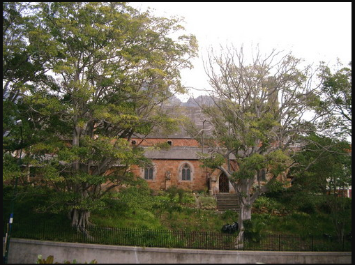
The land upon which this church was erected was granted by Governor Sir Lowrie Cole on 30 August 1832. The original neo-Gothic structure was opened on 16 February 1834 and was extended a number of times thereafter. In October 1854 the original church was incorporated into a new building. Further additions were made in 1857, 1858 and 1909. It was declared a National Monument under old NMC legislation on 29 February 1980.
On 5 September 1832 Bishop Daniel Wilson, the Bishop of Calcutta, Consecrated the Ground on which St Paul's Church stands. Just six days had elapsed since the Governor of the Cape, Sir Lowry Cole approved the grant of this Area of nearly one-and-half Hectares at the foot of Devil's Peak to the People of Rondebosch, for the erection of an Anglican Church.
The clear-cut Boundaries that define the Ground today differ little from those of the original grant; Straight at Church Street and curved at the Main Road. A Lease was later negotiated with the City Council to enable them to encroach onto the Church's Property, to widen the Main Road.
The site itself is interesting because it is at the North end of a rock-based Terrace raised a few metres above the Liesbeek River Valley and it is this foundation that gives the Church its relative Elevation. The Ground was described as Vacant although tradition has it; that Squatters occupied it. Six eminent Citizens had placed the request for the grant of Land before the Governor and they Constituted the first Board of Trustees. One of their number, Major Charles Cornwallis Michell, Government Surveyor, would almost certainly have known of the local Geology so, his recommending this site for Building a Church would have been deliberate. He would also have known that it was crown Land and therefore it would be Freehold. Michell, in fact, Designed the first Church Building.
Other than a surveyed plan of the Land and the prescription of the grant there are no records to show, what improvements were to be made at that time. One intention seems to have been to prescribe a part as a Cemetery. There are still the numerous headstones remaining on the Site and the Church possess a plan showing the layout of Grave Plots. No Burials took place after the end of the nineteenth Century, although the cemetery is still exists it is in need of some preservation work. The Western Cape Branch of the SA Archaeological Society has surveyed the graveyard and captured data concerning the graves and the gravestone inscriptions.
A few artists' impressions of the original Church Building are still in existence, one being by Michell himself and another being by Thomas Bowler, dating from 1848. These two Artists show a difference in the West End Gables. Michell shows a plain Gable, but Bowler shows Castellations. This is because a Porch and the Castellations were added in 1842. Later additions to the Buildings also appear in Sketches, Water-Colours and early Photographs. There is a Photograph taken some time between 1875 and 1880 that shows the current nave of St Paul's Church as an attachment to a less lofty small thatch-roofed Building. The latter corresponds well with what we know of the original Church Building dating from 1834. Apart from the Church Building, Bowler includes an isolated cottage-style Building that might represent the School erected on the Site during the early 1840s. This School, though not the little Building, continued to function without interruption until the end of 1951.
Prior to the grant of this Land for a Church, the site was described by a Preacher; at a Celebration of the fifth Anniversary of the opening of the Church as: 'A receptacle for the veriest outcasts - a scene whereon the wretched aboriginal steeped himself in all those vices which he had learned from the ungodly stranger, a place loathsome to the eye and offensive to the ear'. This seems to imply that with the Building of the Church the presence of Vagrants and Squatters on the Site had ceased. One would like to be able to say that this improvement was Permanent but, alas, vagrancy continues to despoil the St Paul's grounds today.
The Property of St Paul’s, in what is now the midst of the Commercial Centre of Rondebosch, still serves the original purpose for which the six eminent citizens had requested the Governor’s grant of Land- a Church.
References
http://www.stpaulsrondebosch.co.za/ground.htm
Further Reading
https://www.sahistory.org.za/place/rondebosch
https://www.sahistory.org.za/.../south-african-association-art-historians- founded-1984
https://www.sahistory.org.za/.../indiginous-structure-settlement.html
www.sahistory.org.za/.../architecture-general-developing-economy.html