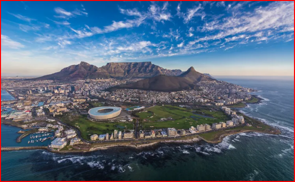
Table Mountain is probably one of the most famous iconic landmarks of the world and dominates much of the picturesque, Cape Peninsula. Extending for 2km from east to west, the level edge of its cliffs which tower nearly 1100m, above Table Bay. It is flanked on the east by Devil's Peak, formerly known as Windburg, and on the West by Lion's Head. Over the years it has accumulated more than its fair share of myths and narratives and remains one of the most popular recreational areas in Cape Town for residents and visitors alike. It was declared a National Monument under old NMC legislation on 8 February 1956 and 1968.
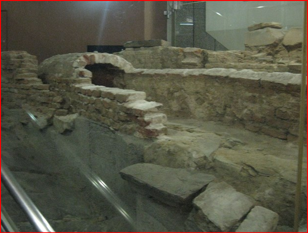
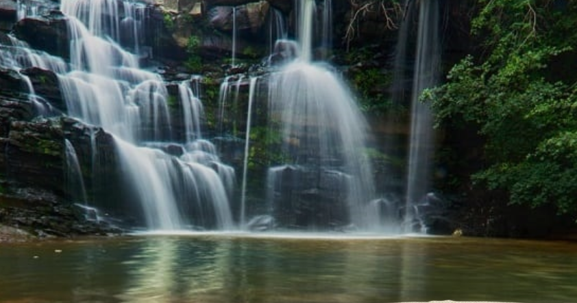
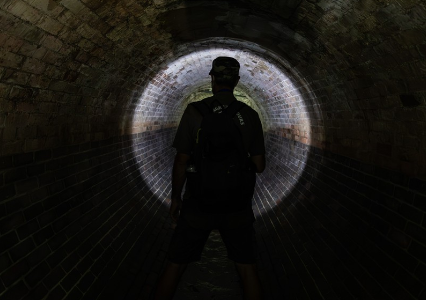
The massive Table Mountain National Park stretches from North of Cape Town down the Cape Peninsula to Africa’s southwestern extremity, the Cape of Good Hope. Iconic, flat-topped Table Mountain is its centrepiece. The mountain’s 1,086m summit affords sweeping views of Cape Town and Table Bay, and is reachable by cableway, bicycle, automobile or on foot. The park is also among the world’s richest floral regions. There are five streams flowing off the mountain: to the North the Varsche River, to the East the Liesbeek; South-East the Diep and Spaanchemat River, whilst the Disa River emerged from Orange Kloof and ran South-West. The most important river, certainly to the Dutch East India Company, was the Varsche, for on it depended the little settlement on Table Bay. The face of the Table is riven by two diagonal gashes: to the right is Platteklip George, to the left of Silverstream. Sturdy rivulets ran down both ravines, joining at the bottom of the sandstone to form the Varsche Rivier that ran straight into the Bay. Immediately after the Dutch arrived they put the Varsche Rivier to work, by watering the newly planted vegetable and fruit garden by dividing it into several channels. One such channel continued to run straight down to the sea, where it served the needs of passing ships. But the Cape is a winter rainfall area, and the normal flow of the river in summer is light; when the drought came in 1663 there was no water for the ships. Van Riebeek had been replaced by Zacharias Wagenaer the previous year, and the new Commander decided to build a reservoir. The 6th August 1663 found the Commander employed with all the gardeners, servants, slaves, soldiers, sailors, boatman, artificers-even the clerks-tolling on the construction of the reservoir. The following day they were joined by 15 young Khoi-Khoi who had been persuaded (no doubt at a price) to help. The reservoir they built was some 45metres long by 15metre wide, and steps ran down to it from which sailors could fill water barrels. Seven years later Commander Jacob Borghorst built a stone watercourse from the water tank to the jetty. Normally such a construction does not survive for posterity, but we are fortunate in that we can see the remains of Wagenaer’s reservoir for these were disclosed, a few years ago when the foundations of the Golden Acre, in Cape Town City Centre, complex were dug. Now fully excavated, part of it has been preserved as a showpiece in the building. Rising on the Eastern slopes of the mountain, the Liesbeek emerges through Window Gorge and Skeleton Gorge. Uniting its sources it turns Northwards and flows into Table Bay. As early as 1656, Rondebosch, on the Liesbeek, had been chosen as an area in which crops could be grown. The Liesbeek River became the centre of the farming settlement and its waters allowed the little refreshment station to expand into a farming colony. The Liesbeek also served another purpose, for it provided a defence line against Khoikhoi cattle thieves. The Southeast flowing waters of Diep River and the Spaanchemat source still further south, near Constantia Nek. Both water the plain between Wynberg and Muizenberg and flow into Zandvlei. The Disa River, too, played its part, enabling farmers to settle in Hout Bay valley in 1681 when Peter van der Westhuizen and William van Deaden commenced farming there. Returning to the Varsche Rivier, there was little in the water position during the eighteenth centaury, except that the grachts began to fall into bad odour-literally, for lazy slaves took to dumping sewerage in the canals instead of the sea. Sir John Rennie was asked to solve the problem. He decided that water had to be brought to the people instead of them fetching it. A reservoir, which could hold 250 000 gallons (1,136Ml) of water, was built in Hof Street in 1814. Iron pipes were laid in Orange, Long and Strand Streets and a number of fountains were built, from which water can be drawn. But, by then Cape Town already had serious water problems! The populations were growing, watermills had been erected in Platteklip Gorge, sharing the use of the water, and the water house was dilapidated and inadequate. Attempts had been made in 1837 to discourage the wasting of water by attaching hand-pumps to the fountains. Now the watermills were brought out, and every possible spring pressed into service-but drought and the growing demand for water defeated all efforts. In 1849 the Superintendent of Waterworks reported that the water was so scarce that he had been obliged to stop street services, and reserve the water for fighting fires. Platteklip was down to a flow of two gallons per minute. The City fathers decided to build a reservoir (No 1), which took two years to complete at a cost of 2700 pounds. It was capable of holding 2 500 000 gallons ( 11,36Ml), and there was an immediate improvement in the water position, but not for long! In 1856 work started on a bigger reservoir (No 2), which was completed four years later at a cost of 8 130 pounds. The combined storage capacity of the dams was 13million gallons (59,2 Ml). Lying between Orange and Hof streets, these two old reservoirs above Camp Street, are still in existence but they no longer store the city’s water. Although these two reservoirs increased the water supply it did not solve the problem. In 1861, adjoining water rights were brought by the council and in 1868 a filter bed was built in Platteklip Gorge, in the bed of the stream. The bed is still there! As the city grew so did the water problems. By 1872, the water consumption reached 400 000 gallons (1.82 ml) per day, a volume with which the storage facilities were quite unable to cope. There was no alternative but to build a really big reservoir, one large enough to cope with the demand! In 1877, work started on the new reservoir which was to be called the Molteno, after Sir John Molteno, the first Prime Minister of the Cape. The Molteno Reservoir took four years to build. It was partially excavated into the slope, the embankments were raised on the other three sides. It was lined with stone pitching and concrete was over 12metres deep, and held 40 million gallons (18,63 Ml). It was opened in 1881 after a particularly dry 1880 and was therefore unable to provide the needed daily volume. On the 27th August 1882 the reservoir wall gave way the upper part of Cape Town was flooded up to waste level and many houses were damaged. The reservoir had to be rebuilt and this took four years and the reservoir has been in use ever since. It is an impressive sheet of water some 300 metre long by 100 metres wide. This sheet of water attracted many seagulls, which caused a pollution problem. This was solved by stringing fishing line at 5netres intervals above the water, this spoilt the gull’s runway, and they gave up on Molteno Reservoir in disgust! It was not until 1887, that work started on Woodhead Tunnel. It was a major effort in those days driving a tunnel 700 metres through the mountain, and construct a pipeline many kilometres in length, with tall aqueducts to carry the pipes to Kloof Nek and then down the mountain to the Molteno Reservoir. The Woodhead Tunnel takes the shortest route through the mountain, emerging in Slangolie Ravine. The tunnel runs horizontally through the mountain with a slight curve. Part of the tunnel was arched in stonework but most of it is raw rock. In place you can still see pegs driven into the rocks. "The view from the exit in Slangolie is breath taking!" The tunnel named after the Mayor of Cape Town, was opened in 1891. However even before the tunnel was completed it was realised that without a reservoir on Table Mountain, the tunnel would be restricted to the low summer flow of Disa Stream. In 1890 work began on the Woodhead Reservoir spanning Disa Gorge, and it was up Kasteels Poort that the builders were forced to bring their materials. Long lines of toiling porters followed a path up the bed of the ravine carrying supplies in the early days of construction. It was impossible to carry all the supplies up the mountain and in 1893 a cable way was erected in Kasteels Poort. The horizontal line of the cable way was 1 600 metres and it rose to a vertical height of 700metres. Open skips were used to carry materials and labour. From the summit station a railway line was laid out and a little steam train (carried piecemeal up the mountain) was used to tow supplies to the dam site. The reservoir was built of masonry with a wall 252metres long stretching right across Disa Gorge and 44m high in the centre. From a base thickness of 19 metres the wall tapers to 3metres at the top.