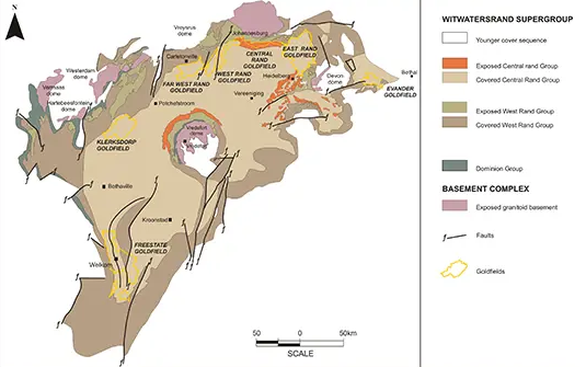
Witwatersrand, ridge of gold-bearing rock mostly in Gauteng Province, South Africa. Its name means “Ridge of White Waters, in Afrikaans.” The highland, which forms the watershed between the Vaal and Limpopo rivers, is about 100 km long and 37 km wide; its average elevation is about 1,700 meters. Its rich gold deposits, occurring in conglomerate beds known as reefs, were discovered in 1886. A heavy in-migration of miners followed, and the city of Johannesburg grew near the centre of the Witwatersrand. The tailing dumps of the gold mines stretch the entire length of the ridge, and chains of lakes created by water pumped from the mines occupy adjoining valleys. Two major theories-the placer model and the hydrothermal model-attempt to account for the origin of gold in the Witwatersrand basin. The placer model holds that gold was eroded from a pre-existing source and transported into the basin with other sediments forming the conglomerate strata. The first recorded discovery of gold on the Witwatersrand was made by Jan Gerrit Bantjes in June 1884, on the farm Vogelstruisfontein, and was followed soon thereafter, in September, by the Struben brothers who uncovered the Confidence Reef on the farm 'Wilgespruit', near present-day Roodepoort.
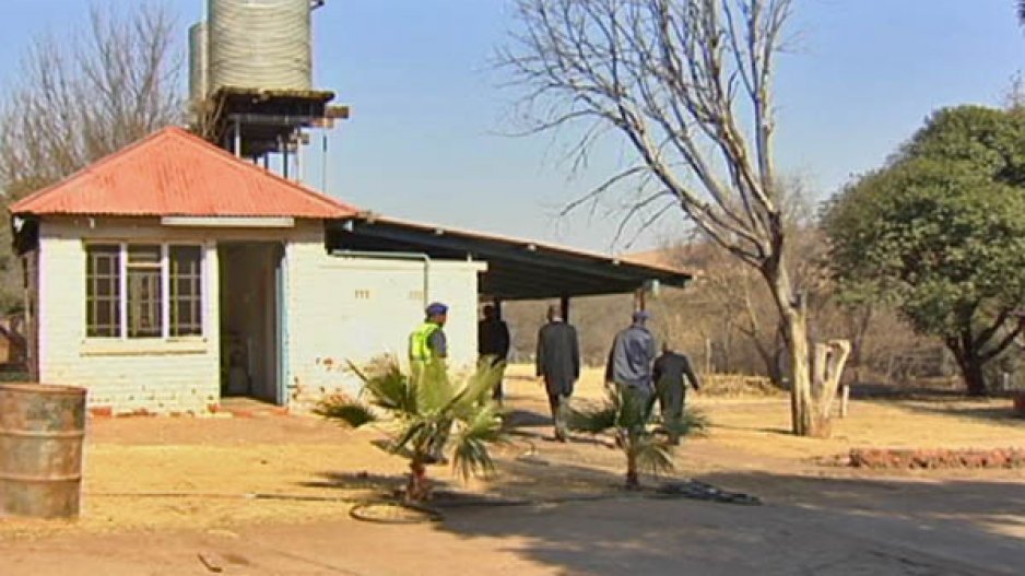
The Witwatersrand Gold Rush initiated South Africa’s domination of World gold production. Although legends of a South African: “El Dorado”, existed among the natives of the Area, it was not until 1886, when a poor Australian prospector named: 'George Harrison', staked the first claim, that the vast riches of the “Rand” were discovered. It took very little time for the local village of Ferreira’s Camp to transform into the Ferreira Township, as miners settled in the region hoping to strike gold. The Witwatersrand Basin still produces most of South Africa's gold and much of the total World output.These operations have weakened geological strata, disrupted natural drainage patterns and altered ecological habitat. The original semi-arid grasslands ecology is now converted to an urban forest, and sediment from mining waste has blocked natural waterways, unexpectedly creating wetlands with rich bird habitat. Massive mine dumps, many upwards of 30 meters tall, have become landmarks of Johannesburg — or "eGoli"-the place of gold, in Zulu. In the 1970's the gold mines moved from Johannesburg and Ekurhuleni to the rural areas of the Witwatersrand, and informal settlements began to occupy the vacant mining lands in the heart of the city.
The end of apartheid, in 1994, brought a large influx of rural residents — mostly blacks or foreign Africans — seeking opportunities in Johannesburg and joining family and friends in existing informal settlements along the mining belt. Currently 25 percent of the population in Johannesburg and Ekurhuleni live in informal settlements, and approximately a quarter of them — 400,000 people — are in the mining belt. The settlements range from 100 to 40,000 people, with the largest communities in Ekurhuleni, where the mining companies have expended fewer resources to police the land.
Not surprisingly, the settlements face a large number of difficulties or problems, typically faced at the same time. Local zoning laws prevent them from receiving Municipal services such as water, electricity and sanitation. Having no secure right to the land, the settlers construct homes from scrap metal and found wood; and despite such resourcefulness, they’ve encountered degraded environmental conditions that seriously hampered efforts to improve living standards and achieve formal municipal status. "Here is some history of the Witwatersrand Gold Style Ore Deposits as they related to South Africa since the arrival of the Dutch and the southernmost tip of the continent in 1652. The Dutch set up a small fort where Cape Town stands today and started Market Gardens as a place that the Dutch East India Company ships to shelter and to restock with freshwater and provisions on the long journey between Holland and East Indies. The East Indies was a vital spice trading destination for the Dutch. As time went on the tiny community expanded and some of the Dutch were allowed to move into the surrounding area to set up new farms on the condition that they still sell their produce to the Dutch East India Company to supply the expanding ship traffic. This arrangement although it was very successful only lasted for a fairly short time before these farmers or Boers as they became known became frustrated by the restrictions set by the company and they started breaking free of the bond and moving inland in their wagons with the Bible in one hand and the rifle in the other. Towards the end of the 1700’s the global influence of the Dutch began to fade and the British moved to fill the vacuum that they left. By 1815 British sovereignty of the Cape was recognized by other European Nations. The influx of British settlers and the imposition of British law infuriated the Boers and they began moving east to escape the British influence although much of the area that they moved into was pretty inhospitable there were still a tough group and they thrived there.
In 1820 the British began their settlement of the Eastern Cape initially as a way of providing a buffer between the advancing Dutch settlers and the indigenous groups to the East. This idea failed but the British were there to stay and they rapidly expanded up the East Coast and then inland. Hindered by the British to the West and the East and by the ocean to the South the Boers climbed into their wagons again and they headed North East seeking new horizons where they can live their lives free of the hated British. They crossed the Vaal rivers and setup two new Boer Republics; The Orange Free state and the Vaal Boer Republic electing their own presidents.-(This is according to Andrew Jackson an Economic Geologist.)