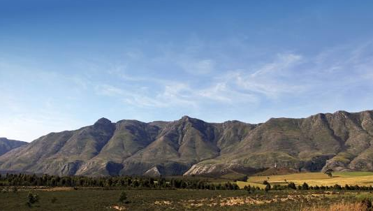
The Langeberg Mountain Range is in the Western Cape Province of South Africa and is approximately 170 km long! The Marloth Nature Reserve, the Garcia State Forest and the Boosmansbos Wilderness Area are three of the most popular Nature Conservation Areas, along the Langeberg Mountain Range! One of several Mountain Ranges that run from East–West in the Western Cape. It stretches 170 km from the Gourits River in the East, to the Town of Montagu in the West. It consists of Sediments of the Table Mountain Sandstone Group and occasionally the Malmesbury Group. South of the Range; the Agulhas Plain and Overberg Wheat-Belt, stretch towards the Coast. To the North lie the open Plains of the Little Karoo. Marloth Nature Reserve is situated in the West of the Mountain Catchment Area, above the Town of Swellendam. The South-facing Slopes above Swellendam, are steep and rise rapidly to form the ‘clock’ Peaks, although in places the steepness is interrupted by expanses of flat Plateau. On the Northern slopes, the Boskloof Valley and Hermitage Kloof rise steeply to form Hermitage Peak, which is 1 154 m above Sea Level and Goedgeloof Peak which is 1 710 m above Sea Level, (the latter being the Highest Point, in the Langeberg range). To the East, Goedgeloof Ridge lies adjacent to the Little Karoo. The Topography towards the Nooitgedacht River is dominated by a series of Peaks: 'Kruispad; 1 365 m above Sea Level, Leeurivierberg; 1 628 m above Sea Level, Middelrivierberg; 1 405 m above Sea Level and Klipspringerkop which is; 1 127 m above Sea Level'. Numerous Streams drain these Mountains, flowing into many of the Western Cape’s; Primary River Systems. These rivers all supply the Agulhas Plain and Overberg, which is known as: 'the Wheat-Belt', with Water! The Plateau-like Southern Slopes at the foot of the Langeberg are deeply cut by, various Rivers. Boosmansbos Wilderness Area, near Heidelberg is more or less Centrally Situated in the Southern Langeberg. Here Grootberg, which is 1 637 m above Sea Level, is the the Highest Peak! There are Fault Valleys at Higher Elevations and to the North, a Series of Sandstone Ridges interspersed with shallow valley's which give way, to a Mesa-Like Plateau of Gravel and Sandstone Conglomerates. The South-facing Slopes above Bergfontein are not as steep as those further West. A prominent, isolated low Ridge, known as the 'Koksposberg', runs along the Front of the Mountain. This Hill and others similar to it, range in Altitude from 457 m to 727 m, above Sea Level. There are no deeply Incised Valleys and the Topography is relatively flat; in comparison to that of the Western Langeberg! In the Garcia Forest Reserve, West of Garcia’s Pass the Peninsula Formation Sandstone, forms some impressive Peaks: Sleeping Beauty, 1 343 m above Sea Level; Korinteberg, 1 330 m above Sea Level; Stinkhoutbos, 1 341 m above Sea Level and Phesanteberg, 1 330 m above Sea Level.
Numerous Watercourses dissect the Sandstone Slopes. To the North of the Langeberg, the Mesic Sandstone Ridge gives way to arid Sandstone Slopes, which in turn make contact with the Bokkeveld Shale, of the Little Karoo! The Langeberg falls in the Transition Zone between Year-round and Winter-rainfall Areas. In Summer, the Mountains trap onshore, moisture-laden, South-easterly winds and Orographic Rain Falls. In Winter, the prevailing North-Westerly and South-Westerly winds bring rain associated with sub-Antarctic cold fronts!Although micro-climates significantly affect local rainfall, in general the lower Slopes receive about 600 mm and the upper Slopes and High Peaks receive 1 400 mm of rain per Annum, falling mostly in Spring and Autumn. Snow and mist occur Annually. Temperatures are moderate and range between 2.9 °C in Winter and 30 °C in Summer!
: 


